Archaeological Investigations at the College Landing National Historic Site
Colonial Williamsburg Foundation Library Research Report Series - 0389
Colonial Williamsburg Foundation Library
Williamsburg, Virginia
2009
Archaeological Investigations at the College Landing National Historic Site
Report submitted to:
City Manager
City of Williamsburg
412 N. Boundary St.
Williamsburg, Virginia 23185
Report submitted by:
Office of Archaeological Excavation
Department of Archaeology
Colonial Williamsburg Foundation
PO Box C
Williamsburg, Virginia 23187
Marley R. Brown III
Principal Investigator
February 1986
Re-issued
August 2001
| Page | |
| List of Figures | ii |
| Management Summary | iii |
| Acknowledgements | v |
| Introduction | 1 |
| Historical Summary | 3 |
| Previous Archaeological Investigations | 12 |
| Methods | 14 |
| Unit Descriptions | 19 |
| Test Unit 1 | 19 |
| Test Unit 2 | 19 |
| Trench A | 20 |
| Trench B | 21 |
| Trench C | 22 |
| Trench D | 23 |
| Trench E | 24 |
| Test Units 3-17 | 25 |
| Test Units 18-29 | 26 |
| Archaeological Features | 27 |
| Eighteenth-Century Warehouse (?) | 27 |
| College Creek Corduroy Road | 27 |
| Paper Mill Creek Corduroy Road | 29 |
| Wharf Pilings | 29 |
| Twentieth-Century Trash Pit | 29 |
| Old Road Bed | 35 |
| Dumping Area | 35 |
| Recommendations | 42 |
| Bibliography | 44 |
| Appendix 1. Layer Descriptions | 47 |
| Appendix 2. Artifact Inventories | 49 |
| Appendix 3. Unit Elevations | 55 |
| Page | |
| Figure 1. College Landing and surrounding area | 2 |
| Figure 2. Bland map (1699) | 4 |
| Figure 3. Matthew Davenport plat (1774) | 6 |
| Figure 4. Berthier map (1781) | 8 |
| Figure 5. St. Simon map (1781) | 9 |
| Figure 6. Desandrouins map (1781) | 10 |
| Figure 7. Map-predicted sites and sites found during 1975-76 | 11 |
| Figure 8. Proposed canal between College Landing and Williamsburg | 11 |
| Figure 9. Test units on City-owned property | 15 |
| Figure 10. North walls, Units 1 and 2 | 16 |
| Figure 11. Test units on College-owned property | 17 |
| Figure 12. North wall, Trench A | 20 |
| Figure 13. Reconstructed profile through destruction layers, Trench B | 21 |
| Figure 14. South wall, Trench C | 22 |
| Figure 15. East wall, Trench D | 23 |
| Figure 16. Reconstructed profile through destruction layers, Trench E | 25 |
| Figure 17. Archaeological features on City-owned land | 28 |
| Figure 18. Corduroy road crossing College Creek | 30 |
| Figure 19. Corduroy road along Paper Mill Creek | 30 |
| Figure 20. Corduroy road along Paper Mill Creek | 31 |
| Figure 21. Detail of Corduroy road on Paper Mill Creek | 31 |
| Figure 22. Reinforcing structure at mouth of Paper Mill Creek | 32 |
| Figure 23. Schematic drawing of reinforcing structure | 32 |
| Figure 24. Wharf pilings on College Creek | 33 |
| Figure 25. Diagnostic marks on bottles | 34 |
| Figure 26. Early liquor bottles | 36 |
| Figure 27. Early machine-made beverage bottles | 37 |
| Figure 28. Various early machine-made bottles | 38 |
| Figure 29. Panel bottles | 39 |
| Figure 30. Archaeological features on College-owned land | 40 |
| Figure 31. Old road bed on ridge along Paper Mill Lagoon | 41 |
| Figure 32. Possible structure on ridge east of South Henry Street | 41 |
| Figure 33. Map-predicted sites and archaeological features in the entire College Landing area | 43 |
Management Summary
In December 1985 the Office of Archaeological Excavation of the Colonial Williamsburg Foundation completed an archaeological investigation of the area around College Landing, an 18th-century port associated with the City of Williamsburg. Two areas were investigated: the City-owned portion of land at the foot of College Landing Road, consisting of the flat landing itself and portions of two adjacent ridges, and the land on the eastern side of South Henry Street owned by the College of William and Mary.
It was anticipated that several structures might be present on the property, including warehouses, a brewery, domestic buildings, and possibly an ordinary. During the 18th century inhabitants of the landing also provided a ferry down College Creek, rented out carts and flatboats, and inspected out-going tobacco shipments. Nearby farms housed a great many slaves, and runaways came to the landing and surrounding farms seeking refuge or escape. By the early 19th century, blacks were being buried on property within the landing.
The archaeological testing proceeded with the certain knowledge that massive land disturbances had taken place in the area during the last several decades. Filling, grading, sand-mining, plowing, and road construction have altered the topography considerably, and it was realized that archaeological features would possibly be covered, damaged, or even destroyed.
The extent of filling on the landing itself necessitated the use of a backhoe to strip off the recent and/or disturbed layers of overburden. Five backhoe trenches were dug on the plain at the end of College Landing Road. Three produced no evidence of 18th-century features, but two-- Trenches B and E-- revealed the remnants of a burned building at about six feet below the surface.
This building, the remnants of which included alternating layers of charcoal, brick rubble, and burnt wood, may have been one of the warehouses shown on late 18th-century maps. Lady Susannah Randolph, the widow of wealthy planter Sir John Randolph, rebuilt a tobacco inspection warehouse on the landing in 1740, while Charles Taliaferro built a warehouse of his own in 1775.
The landing also contained several above-ground archaeological features: two corduroy roads, one of which was probably reconstructed when the creek channel shifted, and at least 28 wharf pilings. These features all appeared, only at low tide, on the extensive mudflats of the two creeks.
The College-owned land east of South Henry Street has been badly disturbed, and no intact 18th-century features were located. Two late 19th or 20th-century features-- an abandoned logging road and a dumping area, possibly with remnants of a structure-- were the only archaeological discoveries.
ivThe alterations to the landscape in recent years probably account for the lack of extensive archaeological remains. The untested portion of the College Landing area, on the ridge on the west side of South Henry Street, is apparently much less disturbed and holds great significance for interpretation of the landing. This land is now privately owned and is scheduled for a high-density housing development. Therefore, while most of the features on the landing and east of South Henry Street are in no imminent danger, it is strongly recommended that the parcel west of the street should be archaeologically surveyed and tested.
Acknowledgements
This project could not have been completed without the help of many individuals. Patricia Samford did most of the background research in addition to assisting with the augering and recording of test holes. Crew member John Cross dug units, recorded trenches, and helped tremendously with the interpretation of the remains. Leslie McFaden handled the artifact processing and wrote the artifact inventories, Virginia Caldwell produced the excellent graphics, and Tamera Mams was kind enough to provide both field and laboratory photography as well as artifact illustration.
Special thanks are also given to David K. Hazzard, for providing us with advice and recollections of his 1975 survey; Charles Thomas, for help with the initial walk-over survey and advice on site interpretation; George Miller, for information on glass bottle technology and dating; Bruce Larson, for assistance with a Virginia Antiquities Act permit; Dudley Waltrip & Sons, Inc., for mechanical equipment; Mary Keeling and John Ingram, for help with library sources; and Steve Martin, City Engineer, for logistical assistance. Finally, a great debt is owed to Carter L. Hudgins, whose outstanding 1977 archaeological report has formed the basis of so much of this work.
Introduction
In December 1985 the Office of Archaeological Excavation of the Colonial Williamsburg Foundation, under contract with the City of Williamsburg, performed a two week archaeological investigation at the College Landing site (44 Wb 3). This site, a National Register property, is located at the junction of College and Paper Mill Creeks, about one mile southwest of the city of Williamsburg. One of the major ports for the city during the colonial period, it was first occupied in 1699, when it was called Princess Anne's Port. In the 18th century it formed a community of its own, consisting of a public tobacco warehouse, several domestic structures, a brewery, a ferry, and a cart and boat rental. By 1774 at least five structures were located at or near the landing. The landing was a tobacco inspection station until at least 1787, and the structures in the area appear to have been occupied into the second decade of the 19th century. Later changes, however, have included a great deal of filling and regrading, in some areas resulting in over five feet of modern overburden.
Two major areas were tested during the 1985 investigation. The most extensive testing was done on the City owned portion of the landing at the terminus of Old College Landing Road. Concurrently, a far less intensive survey was performed on the eastern side of South Henry Street, a portion of land now owned by the College of William and Mary. The locations of these two tested areas are shown in Figure 1.
The City owned land lies at the junction of College Creek and Paper Mill Creek, and consists of a low lying flat plain between two large parallel ridges. A dirt road (Old College Landing Road) leads down to the flat off of South Henry Street; this was the actual terminus of South Henry Street before it was extended along the adjacent ridge to cross Paper Mill Creek and connect with State Route 199. The flat is now almost entirely grass covered, with several small clusters of fir and sycamore trees. Marsh grass covers the areas adjacent to the tidal mudflats on the west and south. The City owned portion also includes 50-100 feet of the toe of the large ridge to the west, a wooded and relatively steep embankment, and a 250 foot long portion of the ridge to the east. This eastern ridge rises about 20 feet above the landing itself, and is capped by a reasonably flat wooded crest.
The College owned land east of South Henry Street can be divided into two parts: a wooded area approximately 300 by 500 feet in size, which comprises the toe and eastern slope of the ridge and drops precipitously to Paper Mill Creek and its smaller tributaries, and a clear cut, grassy area farther north and west, which comprises the ridge top and is now used by the College as an environmental laboratory.
2 Figure 1. College Landing and surrounding area.
Historical Summary1
Princess Anne's Port, later to be called College Landing, was legislatively established in 1699 along Archer's Hope (now College) Creek, less than one mile southwest of Williamsburg. Named for Princess Anne of Denmark, it was one of two ports established for the newly christened capital of the colony, the other being "Queen Mary's Port" (now Capitol Landing), one mile northeast of the town. Princess Anne's Port, offering navigable access to the James River some four miles away, was the larger of the two ports, situated on a piece of land 23 acres, 37 ½ poles in size (Hening 1809-1823:III:432).
The need for the two ports was obvious, if Williamsburg was to become the political and economic center that the legislators envisioned. With Princess Anne's Port offering access to the James (via Archer's Hope Creek) and Queen Mary's Port offering access to the York (via Queens Creek), the new capital seemed well situated for trade and commerce. In fact Governor Francis Nicholson clearly espoused the benefits of such a location, "at an equal distance from James and York Rivers, between two creeks, which afford the conveniency of water carriage from each of them…[and which are] navigable with the tide by any kind of shallop, or flat bottomed boat" (Goodwin 1930:3; Keith 1738:171).
Other landings along the James River‒Burwell's Landing and Jamestown‒were also utilized and thus acted to reduce the flow of commerce through Princess Anne's Port. It seems clear that it was never a particularly large port, but an apparently steady flow of goods to and from Williamsburg ensured its close connections with the capital throughout the succeeding century (Hudgins 1977).
The first survey of the area was by Theodorick Bland in 1699 (Figure 2). His map shows a clearly pentagonal area bounded on the west by Archer's Hope Creek and on the south and east by its tributary (later termed Paper Mill Creek after establishment of a paper mill on its shores in the mid 18th century). The landing itself was connected with Williamsburg by a road passing through the large ravine southwest of the city and almost certainly following the same general path as Old College Landing Road does today. Although the exact locations of particular lots are not shown on Bland's map, surviving legislative records indicate that lots in the pentagonal area were established, 60 feet square (Hening 1809-1823:III:427) and on either side of the landing road. No records, unfortunately, indicate the initial purchasers of the lots, or the number of lots that were actually seated (Hudgins 1977:13).
Apparently it was not until 1720 that the lots were actually surveyed. Town surveyor Christopher Jackson, who in 1715 had surveyed the port area at the end of the road, seems at this time to have laid out property divisions over the whole area. Again, unfortunately, this record does not survive.
4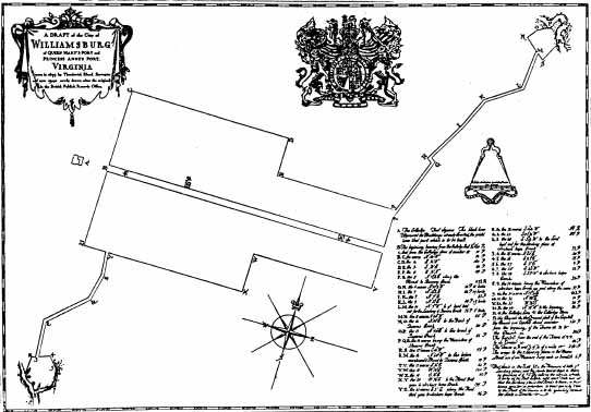 Figure 2. Bland map (1699).
However the lots were laid out, it is clear that by the second decade of the 18th century there was a certain amount of activity at Princess Anne's Port. In 1715 lawyer John Holloway had received 833 square feet of land (or, more precisely, water) at the base of the landing, upon which he had constructed a wharf (Duvall 1979:77). Presumably this served primarily for the shipment of tobacco and other goods. By 1705 a public ferry had been established, transporting passengers between the landing and Hog Island, roughly four miles to the south across the James River.
In May 1730 the General Assembly of the colony instituted a long debated system of tobacco inspection. Warehouses were established 12 to 14 miles apart alongside navigable waterways, and Princess Anne's Port, meeting the necessary criteria, was designated as an inspection station; so was Queen Mary's Port, about two miles northeast on the banks of Queens Creek. After its initial failure in 1713, blamed largely on internal inefficiencies and the recalcitrance of the planters, it was questionable whether tobacco inspection had a future in Virginia.Yet the 1730 inspection act was to be successful, and this system was to persist throughout most of the rest of the century and would provide a quality control heretofore lacking.
John Holloway owned the land chosen for the inspection stations at both Princess Anne's and Queen Mary's Ports. The public tobacco warehouses he thus established, for which he was paid a yearly rent, must have changed the character of each port. As both were operated as a single inspectorate, however, it appears that neither accomodated an enormous volume of trade (Hudgins 1977:20).
5As noted by McCartney, "the duty of the inspector was to break open each hogshead or cask of tobacco brought to his station, remove or burn any trash or bad tobacco contained in the hogshead, and issue notes to the planter specifying the weight and type of tobacco tendered" (1976:4). The first recorded inspector at Princess Anne's Port, Captain Pierce, died in 1738. Thomas Cobbs, a carpenter by trade, shared the post with Benjamin Eggleston until 1750; Eggleston was replaced in 1751 by Henry Tyler, a builder, contractor, and undertaker (McCartney 1976).
By mid century the ownership of the tobacco warehouses had changed. After John Holloway died in 1734, the warehouses became the property of Sir John Randolph, one of the wealthiest landowners in the area. Following his death in 1737, the property passed to his wife Susannah, who held it in trust for her son Peyton. In 1740 Lady Susannah was required to rebuild one of her warehouses at the landing, a 20 by 40 foot building that she rebuilt at her own "considerable expense," for which she brought a suit for compensation from the government (McIlwaine 1910:399-400). She was hardly destitute, however, having large holdings in and around Williamsburg, including a farm on the eastern side of College Landing Road reputed to be harboring runaway slaves (Parks 1745).
The landing was certainly an attractive place for runaways of all types, as it seems to have been a port of call for ships bound for New England, the West Indies, and Great Britain as well as more local destinations. Not only were goods imported for sale by Williamsburg merchants, but sometimes they were even sold at shipside. By 1778 a French schooner was offering nails, cordage, and brandy at the landing (Purdie 1778a); in 1779 both Muscavado sugar and French rum were sold there as well (Dixon 1779b). Outbound ships carried not only tobacco, but also pitch, tar, leather, and raw agricultural products (Hudgins 1977:27). To meet the demand for storage space at the landing, by 1775 Williamsburg craftsman Charles Taliaferro had built a warehouse on the western side of College Landing Road, where he would store:
"any kinds of goods, where are to be sold (on low terms, for cash) salt, tar, barrelled Pork, Hogs lard, Bacon, good barrelled Shads and Herrings, coal for smiths and grates, Pine Plank, Cypress boards, Pails, Shingles, &c" (Dixon 1775).He also offered carts and boats for rent, and lodgings for travelers at the home of his agent, James Jordan.
Ordinaries normally provided for these needs, for ships' crews and for merchants and planters alike. No less than four ordinaries received licenses between 1715 and 1728 (Reps 1972:177), but McCartney (1976) found no reference to a true ordinary ever having been established at the landing.
The flatboats that were for hire may have been controlled by the keeper of the ferry. In 1774 a John Roan advertised in the Virginia Gazette for boatmen, asking for:
"a careful person that is capable of being Skipper…[and] two or three more Persons who are able and willing to work by Water" (Purdie and Dixon 1774).6
Along with all the other activity at the landing, Charles Taliaferro appears to have operated a brewhouse. In 1779 he advertised for a quantity of barley, to be used at:
"his brewhouse [at] the college landing" (Dixon 1779a).
Runaway slaves had become a problem at the landing. Newspapers regularly seem to have carried notices of runaways seen there, hiding out or attempting to board ships (Hunter 1763; Purdie 1778b; Mullin 1972). The amount of activity and the relative anonymity of the travelers and ships' crews are suggested as reasons why runaways were so attracted to the place (Hudgins 1977:28-29).
In 1774 enough confusion existed about lot boundaries to cause a re survey of the entire area. Town clerk Matthew Davenport created a meticulous plat showing 78 lots, 36 on the west side of College Landing Road and 42 on the east side (Figure 3). Topographically the lots were thus arranged on the tops of the two parallel ridges east and west of the road which, meandering through the large dividing ravine, led down to the flat plain on which the landing itself was situated. The lots were divided into groups of six, each separated by one of the eight
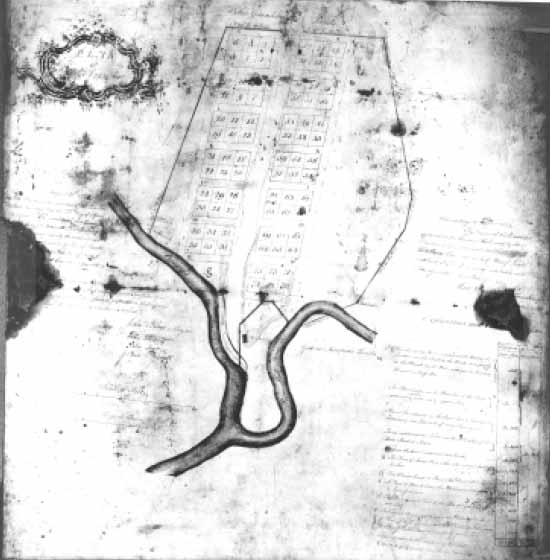 Figure 3. Matthew Davenport plat (1774).
7
cross streets. A narrow area on the west side of the platted area, and a much larger one on the east side, were left undivided, as was the plain at the foot of the landing itself. Two small triangles of land (marked "e"), 1½ lots in size, are shown abutting a larger section of land ("f " and "c") that is noted as belonging to John Greenhow. Greenhow, a merchant, had evidently purchased this large section, which included the warehouse and wharf at the base of the landing, from Peyton Randolph some time before.
Figure 3. Matthew Davenport plat (1774).
7
cross streets. A narrow area on the west side of the platted area, and a much larger one on the east side, were left undivided, as was the plain at the foot of the landing itself. Two small triangles of land (marked "e"), 1½ lots in size, are shown abutting a larger section of land ("f " and "c") that is noted as belonging to John Greenhow. Greenhow, a merchant, had evidently purchased this large section, which included the warehouse and wharf at the base of the landing, from Peyton Randolph some time before.
The plat shows five individual structures: a small rectangular block in the southeastern corner of lot 2 (possibly owned by John Roan [McCartney 1976]), a similar block across the road on lot 37, another block in the northeastern corner of lot 45, a labeled "Well" between lots 92 and 93, and a labeled "Warehouse" at the foot of the "Main Street" (College Landing Road). This warehouse, apparently situated on the eastern side of the road, but below the bluff of the eastern ridge, is said to belong to Greenhow. A large area, however, is shown along Archer's Hope (College) Creek and labeled "The Landing Commons," representing an area held in common and therefore outside of Greenhow's control.
By the Revolutionary War Princess Anne's Port, now renamed College Landing, was functioning both as a center of commerce and as a military provisioning port. Before and during the siege of Yorktown, French and American military personnel visited the landing; after the siege, a small French garrison was established there (Hudgins 1977:31). In the course of these actions, French military cartographers meticulously mapped the area in and around Williamsburg, including the landing. Three important maps show the area in some detail. The 1781 Berthier map (Figure 4) shows eight structures: four beside the road, one on the ridge on the eastern side of the landing, and three on the flat landing itself. The 1781 St. Simon map (Figure 5) shows six structures: four on the landing and two at the top of the western ridge. Finally, the 1781 Desandrouins map (Figure 6) shows six structures: two on the road, two at the top of the western ridge, and two on the plain next to Paper Mill Creek. Although the placement of these structures varies slightly from map to map, it seems clear that at this time the area contained several structures of one kind or another. The relationship of these structures to each other, and to the features discovered during archaeological investigations in 1975-1976, is shown in Figure 7.
McCartney (1976) has suggested the possible functions of some of these buildings. The building closest to College Creek on the Berthier and Desandrouins maps, she believes, may have been Taliaferro's warehouse. Farther north, still on the western side of the landing, may have been Taliaferro's brewhouse and the home of his agent, James Jordan.
After the War College Landing continued its commercial functions for a few years; the last recorded tobacco inspection was in 1787 (Palmer 1884:IV:377), but the inspector's salary is recorded until 1792 (McCartney 1976). Presumably ships continued to intermittently come and go, although the more successful landing at Burwell's Ferry may have siphoned off some business. The public ferry at College Landing continued until 1785 (Hudgins 1977:28).
Although John Greenhow had attempted to sell his property at the landing in 1774 and 1778, it was still, for whatever reason, in his possession at his death in
8
 Figure 4. Berthier map (1781).
1787. The property then passed to his son Robert, who sold it to Littleton Tazewell in 1799 (McCartney 1976).
Figure 4. Berthier map (1781).
1787. The property then passed to his son Robert, who sold it to Littleton Tazewell in 1799 (McCartney 1976).
By this time a little more appears in the records about the actual owners of some of the lots in the northern part of the platted section. Stephenson (1951) states that a William Abrahams owned lots 37, 38, 39, 42 and 44 in the early 19th century, although the reference that she used has not been subsequently found (McCartney 1976). However, in 1834, Dickie Galt purchased the lands east of College Landing Road from a Lucy Quinn, who herself had purchased the lots from Robert Jonathan and wife (Southall 1771-1850). McCartney (1976) believes that Jonathan may have been the owner of the lot 45 structure
9
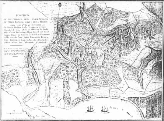 Figure 5. St. Simon map (1781).
shown on the Davenport plat. Meanwhile, the western side of the road and the landing was still in the Tazewell family until December of 1834, when Galt purchased this land as well (Southall Papers 1771-1850). The landing itself was apparently little used. As early as 1794 a cannon had been installed near the creek (Palmer 1884:VII:175), and it was still there in 1804 (1884:VII:400-401).
Figure 5. St. Simon map (1781).
shown on the Davenport plat. Meanwhile, the western side of the road and the landing was still in the Tazewell family until December of 1834, when Galt purchased this land as well (Southall Papers 1771-1850). The landing itself was apparently little used. As early as 1794 a cannon had been installed near the creek (Palmer 1884:VII:175), and it was still there in 1804 (1884:VII:400-401).
In 1818 the Virginia Canal Company suggested the construction of a canal between the landing and Williamsburg. The plan, fortunately, fell through. The map of the proposed canal, however, does show two interesting features (Figure 8). A "county wharf" is shown at the junction of College and Paper Mill Creeks, suggesting that the Commons area was still used for shipping, and a labelled "Gambols" is shown near the wharf, suugesting the presence of an ordinary or tavern. It is unclear, however, whether this map depicts actual conditions at the time or is simply a conjectural plan of what the area would look like once the canal was built.
With the exception of the title changes mentioned above, College Landing fades into obscurity during the succeeding years of the 19th century. By the time of the Civil War, it appears very infrequently in historical records.
In the later 19th century the area on the eastern side of College Landing Road was purchased by Eastern State Hospital to be used for a farm to feed patients and hospital staff. In 1879 the administrators purchased "Munford's Meadow," a 16 acre tract some 1600 yards south of the hospital (Hudgins 1977). The name "Munford's Meadow" suggests that it was purchased from Colonel John D. Munford, the owner of the large home called Tazewell Hall and probably a large portion of the lands once owned by the Tazewell family.
10 Figure 6. Desandrouins map (1781).
Very little is known about the 20th century changes to the area, although they must have been considerable. The eastern side of the road has apparently been used as a farm, a pasturage, and a tree farm (Hudgins 1977). Much of this area has also been used as a borrow pit, thus obliterating archaeological features. Finally, the changes associated with construction of the roads, even up to the extension of South Henry Street in the 1970s, have altered the topography of the entire area and resulted in the loss of several sites.
11 Figure 7. Map-predicted sites and sites found during 1975-76.
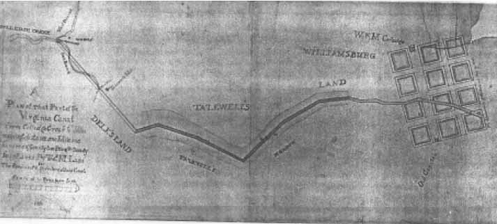 Figure 8. Proposed canal between College Landing and Williamsburg.
Previous Archaeological Investigations
In 1975 the Virginia Department of Highways and Transportation contracted with the Virginia Research Center for Archaeology to perform an initial archaeological survey of the College Landing area, in preparation for the extension of South Henry Street across Paper Mill Creek. Under the supervision of VRCA archaeologist David Hazzard, the survey isolated several probable locations of historic activity. These included: the structures on lots 2, 37 and 45 of the Davenport plat, the well between lots 92 and 93, a warehouse (?) on the plain at the foot of the landing, and a surface artifact scatter on the western ridge above the landing (Hudgins 1977:4-5, Fig. 3). These sites are shown in Figure 7.
Based on the results of the initial survey, the VRCA recommended controlled excavation of two sites in the right of way of the proposed South Henry Street extension. These two sites‒the structure on lot 37 and the well between lots 92 and 93‒were excavated by Carter Hudgins and others in 1976 (Hudgins 1977).
A small domestic structure on lot 37 was found under 4-14 inches of overburden. Represented by the robbed walls of a brick cellar foundation, the structure was 16 by 20 feet in size with an exterior chimney base and bulkhead foundation along the southern wall. This is almost certainly the structure shown on the Davenport plat and on the Revolutionary War era maps of the area. Based on his archaeological information, Hudgins reconstructed it as a one and one half story frame structure, built around 1750-1760 and destroyed about 1815.
During grading an associated feature was found thirty feet south of this structure. The feature, a backfilled colonial well, was not shown on the Davenport plat. Filled during the 1770s, it may of course have no longer been extant when Davenport did his survey in 1774, thus providing a particularly vivid example of the dangers of relying solely on late 18th century maps for reconstructing the colonial landscape.
The other area excavated by Hudgins was the supposed location of the well shown straddling lots 92 and 93. Stripping of this area revealed, in addition to the colonial period well, an area of intense activity throughout the 18th and early 19th centuries. The area thought to be the well during the survey turned out to be a backfilled basement from a building constructed after 1860, probably associated with a water pumping station for Eastern State Hospital. South and west of this basement was another partial basement, this for a colonial structure probably demolished between 1720 and 1740. A nearby root cellar and partial chimney base were probably part of the same structure, which was also associated with a series of drainage ditches running in several directions. This structure, unknown before its fortuituous appearance during the stripping, is the earliest feature now known at the landing. Also associated with the structure was a nearby refuse pit and a so called "craft area," a 1.9 foot deep trench that Hudgins suggests may have been either a hemp soaking pit, a flax soaking pit, or some sort of watering trough (1977:57).
13The most unexpected discovery, however, was a group of some 20 late 18th early 19th-century human burials. These individuals, all interred between 1790 and 1820, were apparently exclusively black, and osteological analysis has suggested that they may have been involved in craft activities associated with the artisan trades (Hudgins 1977:75). All 20 were excavated, as they lay within the proposed South Henry Street right of way.
No extensive excavations were performed on any of the other five sites discovered during the 1975 survey. Three of these sites now lie within the proposed Port Coves housing development, one on the College owned side of South Henry Street, and one (the "warehouse [?]") on the flat plain at the base of College Landing Road. Only the latter two fell within the boundaries of the 1985 investigation.
Methods
The 1985 investigation of the landing was predicated both on historical evidence, suggesting the presence of a number of structures in the area, and the results of the 1975-1976 investigations, pinpointing likely activity areas based on archaeological observation.
The intensity and nature of the 1985 investigation was affected by several considerations, among them topography, cartographic evidence, and likely depth of deposit. On the City owned portion west of South Henry Street, two major environmental zones were represented: the flat plain beside the creeks, and the ridges on either side of this plain. In both cases the depth of any cultural deposits was not immediately known.
Auger holes were initially placed in these areas to determine the nature of the upper parts of the deposits. Using a three inch diameter soil auger, nine holes were dug in various locations (Figure 9). All eight holes dug on the plain indicated that no 18th century cultural layers were present in the upper three feet, but that these upper layers were a confusing mix of hard orange clay, tan and gray sand, and occasional loams of various types. On the top of the eastern ridge, the auger hit a layer of apparently sterile subsoil directly beneath the topsoil layer; no fill layers were evident.
Based on the results of this augering, and from David Hazzard's recollections of his 1975 survey (from which he remembered that most of the plain seemed to be covered by 3.5 to 4 feet of fill), it was determined that a backhoe would be required to strip off the overburden. To confirm this, and to gain a slightly better idea of the type of fill layers involved, two 2.5 by 2.5 foot test units (Units 1 and 2) were excavated south and southeast of the terminus of the old road. These units were excavated to 1.4 feet and 1.8 feet below grade respectively, then augered. The units revealed only successive layers of fill and/or wash deposits making very little stratigraphic sense (Figure 10).
The five backhoe trenches (Trenches A E) were dug through various portions of the landing, depending mostly upon topography and cartographic evidence. Whenever possible, the trenches were taken to natural subsoil. Trenches A, C and D were dug as long rectangular units, 6-10 feet wide and up to 35 feet long. Trenches B and E were excavated as large 12-15 foot squares in order to expose as much horizontally as possible, as it was in these squares that the destroyed warehouse (?) remains were found. In all cases recording was necessarily kept to an absolute minimum, as seepage of ground water into the trenches made them dangerously unstable.
The testing strategy on the ridge tops differed greatly, since it appeared that any cultural deposits would be at or near the ground surface. Fifteen small test holes were dug at the top of the eastern ridge. These shovel pits (Units 3-17) were taken to natural subsoil, usually less than one foot below grade. In addition, auger holes were placed at roughly 20 foot intervals along the ridge top, and portions of the eroded slope were cut away to expose underlying stratigraphy.
15
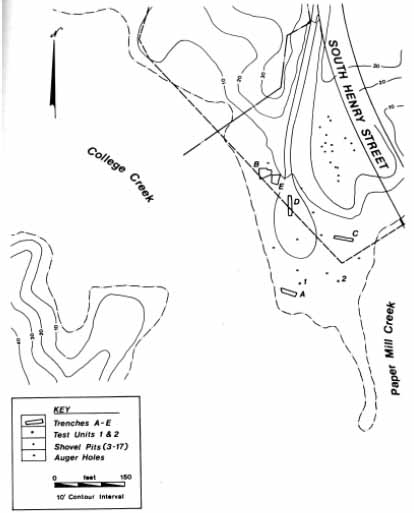 Figure 9. Test units on City-owned property.
The City owned portion of the western ridge was topographically unsuitable for structural remains, being composed almost entirely of a relatively steep embankment leading down to the landing. A few auger tests on this ridge revealed what was apparently subsoil directly below the topsoil layer.
Figure 9. Test units on City-owned property.
The City owned portion of the western ridge was topographically unsuitable for structural remains, being composed almost entirely of a relatively steep embankment leading down to the landing. A few auger tests on this ridge revealed what was apparently subsoil directly below the topsoil layer.
The College owned land on the eastern side of South Henry Street was only cursorily inspected (Figure 11). Small one foot diameter shovel pits (Units 18-29) were dug in the clear cut northern section, while auger tests at 50-75 foot intervals were performed in the wooded sections. The clear cut section seemed characterized by a topsoil and mixed fill layer underlain by subsoil; no clearly intact cultural layers were found in any of the shovel pits. The wooded sections revealed
16
 Figure 10. North walls, Units 1 and 2.
17
Figure 10. North walls, Units 1 and 2.
17
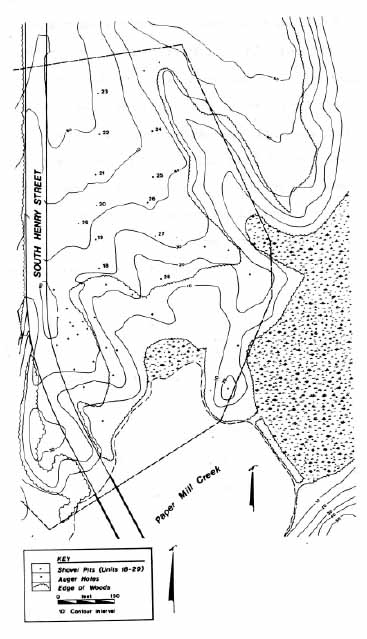 Figure 11. Test units on College-owned property.
18
only a topsoil layer underlain by subsoil; again no cultural layers were identified. Nonetheless it must be stated that this preliminary survey was extremely superficial, and should not be viewed as sufficient investigation to warrant writing the area off for development or land modification.
Figure 11. Test units on College-owned property.
18
only a topsoil layer underlain by subsoil; again no cultural layers were identified. Nonetheless it must be stated that this preliminary survey was extremely superficial, and should not be viewed as sufficient investigation to warrant writing the area off for development or land modification.
All discernible layers or features, from any of the test units, were assigned context numbers in the field. Standard data on soil conditions, stratigraphic relationships, and artifact content were recorded on data entry forms. For mapping purposes, two datum points were established: at the northwest corner of the concrete pad under a Cheaspeake and Potomac Telephone Company control box on the east side of the flat plain, and at a telephone pole in the center of the eastern ridge on the west side of South Henry Street. Units and auger locations on the College owned portion east of the street were estimated on the basis of mapped vegetation boundaries and topographic contours.
Layers and features were dated by use of the terminus post quem (literally, "the date after which"). This date is established by identifying the artifact type in each context which is the newest or most recent one in terms of period of manufacture. This is the earliest point in time that an assemblage or soil layer could have been deposited. It could, of course, have been deposited any time after that date.
The trench contained several large wooden wharf pilings at various depths, all apparently broken and displaced. Undoubtedly the deposit has been churned about, and no intact structural features were present. Artifacts included English hard paste porcelain, a slip trailed redware bowl, a glass pitcher handle, and a shotgun shell.
Unit Descriptions
Test Unit 1
Test Unit 1 was dug some 60 feet south of the terminus of Old College Landing Road in a picnic area surrounded by sycamore trees. This unit was located very near the location of one of Hazzard's test holes in 1975, where he recorded wooden remains up to 4 feet below the surface, interpreted as possible warehouse remains (Hazzard, pers. comm.). Unit 1 revealed four soil layers: a 0.1 foot topsoil layer (context WB3-005); a 0.2 foot layer of compacted yellow orange sand probably used as a road base (WB3-006); a 0.2 foot layer of brown loam (WB3-007); and a layer of yellow brown clay fill (WB3-008), which continued to 1.4 feet below surface. The unit was discontinued at this point. An auger hole in the bottom of the unit revealed that the yellow brown clay continued to 2.8 feet below surface, upon which the soil changed to a sterile appearing gray sand (WB3-012).
Artifacts in the unit were mostly modern types, and including among other things a piece of bone china, a 20th century liquor bottle, and an aluminum toy token marked "Look/Savings Medallion."
Test Unit 2
Test Unit 2 was placed about 80 feet east of Unit 1 and some 50 feet from the edge of the mudflat. Seven layers were identified: a 0.4 foot topsoil layer (WB3-001); a yellow clay mixed with sand and pebbles (WB3-002); a light brown gray loam (WB3-003); a lens of granular pebbles (WB3-004); a hard compacted clay with shell fragments (WB3-010); a shell fragment wash (WB3-011); and a silt layer (WB3-009). The unit was discontinued at 1.8 feet below ground surface, but an auger hole in the bottom revealed that the silt continued at least to 3.3 feet below surface.
The only significant feature of any kind was a squarish postmold (WB3-057) near the northern edge of the unit, first found at 1.3 feet below surface. The post was evidently driven into the hard compacted clay with shell (WB3-011), and probably represented part of a fence line running northwest southeast along the edge of Paper Mill Creek. No artifacts were found in the postmold or in the layers that it cut through, so the construction date for the fence line could not be determined. The general nature of the fill in the area, however, suggests that it could hardly be earlier than the latter part of the 19th century.
Artifacts in the unit were almost all modern types, with green beer bottle glass, a wire nail, and a piece of non leaded bottle glass.
Trench A
Trench A was dug through the area just south of Unit 1, about 50 feet from the edge of the mudflat. The trench was roughly east west, about 30 feet long and 10 feet wide. A 10 foot section drawn along the south wall (Figure 12) represents the general stratigraphy of the entire trench. This section shows six layers: WB3-058, a brownish yellow sand fill, ranging from 1.3 to 1.9 feet thick; WB3-059, a dark gray sandy deposit 0.5 to 1.5 feet thick; WB3-060, a series of lenses of washed and redeposited clayey sand, 0.5 to 1.2 feet thick; WB3-062, a series of lenses of washed and waterlogged clayey sand, 1.2 to 2.0 feet thick; WB3-063, a 0.2 foot thick layer of oyster shell seen only on the western side of the trench; and WB3-064, a series of lenses of gray and tan sand intermittently dotted with shell and brick bits, up to 1.3 feet thick. Below this layer, at a depth of five to six feet below the surface, was a natural gray sand subsoil.
The trench contained several large wooden wharf pilings at various depths, all apparently broken and displaced. Undoubtedly the deposit has been churned about, and no intact structural features were present. Artifacts included English hard paste porcelain, a slip trailed redware bowl, a glass pitcher handle, and a shotgun shell.
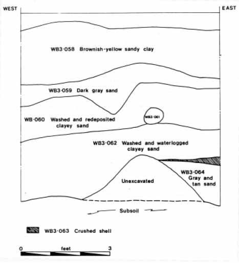 Figure 12. North wall, Trench A.
Trench B
Trench B was excavated on the western side of Old College Landing Road, along a grassy flat. A 12 by 15 foot trench was excavated in order to expose a wide area.
The top five feet of soil consisted of fill layers: WB3-065, a 0.3 foot thick layer of dark grayish brown topsoil; WB3-066, a 2.8-3.0 foot layer of orangish clay fill, containing modern glass and brick; WB3-067, a layer of silty sand with shell pockets, 0.7 to 1.0 feet thick; and WB3-068, a 1.1 foot thick layer of red and gray striated sand with orange clay mottling (Figure 13). The latter two layers sloped downward toward the west in the direction of the shoreline; the orangish clay fill layer was probably dumped on top of them when the ground was levelled.
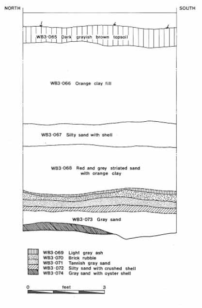 Figure 13. Reconstructed profile through destruction layers, Trench B.
At 5.8 feet below surface a series of destruction layers was discovered, possibly relating to the 18th century warehouse. These layers, a total of 0.9 feet thick, consisted of: WB3-069, a 0.1 foot light gray ashy layer; WB3-070, a 0.2 foot thick layer of brick rubble; WB3-071, a tannish gray layer under the brick rubble; and WB3-072, 0.15 foot thick layer of oyster shell mixed with silty sand. Below this came WB3-073, a possibly sterile layer of gray sand, and WB3-074, a layer of gray sand with apparently natural crushed oyster shell deposits.
Most of the artifacts came from the striated sand lenses directly above the destruction layers (WB3-068). They included 18th century types such as creamware, pearlware, and Westerwald blue and gray stoneware. A wine bottle base at the bottom of this layer appears to be of a type manufactured around 1790. The destruction layers themselves, unfortunately, contained no datable artifacts. Two hand wrought nails, a length of iron chain, and a piece of bone were the only finds.
Trench C
Trench C was located on the eastern side of the landing, about 30 feet south of the eroded bank of the eastern ridge. The trench, 6 by 55 feet in size, was dug in an east west direction.
As shown in Figure 14, Layer 1 (WB3-075) was a 1.0 foot thick layer of orange clay fill, apparently deposited in the last few decades. Directly below this, in the southern portion of the trench, was a crescent shaped trash pit, containing hundreds of early 20th century glass bottles. This trash pit, more fully described in the following chapter, was composed of: WB3-076, a very dark brown loam up to 2.5 feet thick, and WB3-077, a 0.5 foot thick layer of very dark brown loam mixed with a large amount of charcoal. As none of the bottles seemed to be burned, it would appear that this lower layer was deposited before the bottles
 Figure 14. South wall, Trench C.
23
were dumped. At the bottom of the charcoal layer were two isolated lenses of crushed oyster shell (WB3-077 and WB3-078), each up to 1.5 feet thick. These lenses may correspond to a slightly thicker oyster shell layer (WB3-081) found directly under the orange clay fill in the northern section of the unit; it was apparently through this layer that the trash pit was cut. Below all of these layers was a natural appearing gray sand subsoil (WB3-080).
Figure 14. South wall, Trench C.
23
were dumped. At the bottom of the charcoal layer were two isolated lenses of crushed oyster shell (WB3-077 and WB3-078), each up to 1.5 feet thick. These lenses may correspond to a slightly thicker oyster shell layer (WB3-081) found directly under the orange clay fill in the northern section of the unit; it was apparently through this layer that the trash pit was cut. Below all of these layers was a natural appearing gray sand subsoil (WB3-080).
All artifacts from this trench were found in the upper portion of the trash pit (WB3-076). These included some 50 complete or almost complete bottles, a few ceramic jugs and pitchers, and several uncollected fragments of metal.
Trench D
This trench was excavated in a north south direction through the grassy area in the middle of the loop forming the terminus of College Landing Road. A 6 by 50 foot trench was excavated, although its walls began to collapse even as it was being dug. A quickly sketched profile (Figure 15) revealed two major layers: WB3-082, a 1.5 foot thick layer of orange clay fill mixed with a bit of topsoil; and WB3-083, a 3.5 foot layer of tannish clayey sand fill. At about five feet the soil changed to a natural appearing pale tan gray sand. No destruction layers similar to those found in Trenches B and E were discovered. Because of the danger of
 Figure 15. East wall, Trench D.
24
collapsing walls, no artifacts were collected, but those observed indicated that the entire five feet of excavated material was probably fairly recent fill.
Figure 15. East wall, Trench D.
24
collapsing walls, no artifacts were collected, but those observed indicated that the entire five feet of excavated material was probably fairly recent fill.
Trench E
The final backhoe trench was excavated in the same general area as Trench B, where destruction layers possibly related to an 18th century warehouse were unearthed. Trench E was about 10 by 12 feet in size and was excavated northeast of Trench B, since the possible colonial layers were more evident on the northeastern side of the latter unit.
The ground surface was slightly higher in the area of Trench E, and the first 6.9 feet was composed of fill layers corresponding to those found in the upper six feet of Trench B. In this case the layers of fill seemed much more mixed, however, resulting in the clear definition of only one context (WB3-085), a orange brown sandy clay fill with intermittent pockets of cleaner gray and tan sand (Figure 16).
At about six feet below surface, however, a pile of brick rubble was discovered. This pile (WB3-086), up to 1.0 feet thick, was partially underlain by a pile of crushed oyster shell (WB3-087). Located mostly on the eastern side of the unit, both sloped away rapidly and seemed to represent an isolated deposit. After this material was removed, the first clear destruction layer was revealed at 6.9 feet below surface, mostly on the western side of the trench. Evidence of burning was provided by a 0.1 foot layer of charcoal (WB3-088) atop a 0.2 foot layer of decomposing brick rubble (WB3-089). The decomposing rubble was underlain by a thin layer of burnt clay and pinkish ash (WB3-090), which in turn covered a 0.15 foot layer of charcoal (WB3-091). Directly under these layers was a thicker layer of gray sand (WB3-092) mixed with shell and brick chips, containing numerous chunks of burnt, almost petrified wood. After this came a gray sandy subsoil (WB3-093), matching the subsoil found directly under the crushed shell pile in the eastern half of the trench.
The bottom of the orange clay fill layer (WB3-085) produced a few 18th century artifacts, including a piece of creamware, a pipe stem fragment, and a piece of black glazed stoneware. The destruction layers themselves, however, yielded few datable artifacts, although among them was a machine cut and headed nail found in a brick rubble layer (WB3-090). This artifact indicates that the building must have been destroyed after 1805, when these types of nails were first made. Other artifacts in the destruction layers included only isolated pieces of ceramics, hand wrought nails, and burnt wood.
Test Units 3-17
These fifteen shovel pits, on the top of the ridge east of the landing, were almost totally barren of any evidence of cultural activity. Topsoil layers ranged from 0.3 to 1.0 feet in depth, underlain by a tan silty clay subsoil. The shovel units were spaced to cover the majority of the ridge top; additional auger testing insured that no likely areas were missed.
25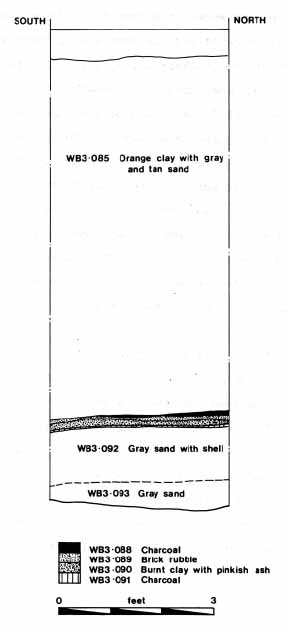 Figure 16. Reconstructed profile through destruction layers, Trench E. Dashed line represents layer boundary interpolated from adjacent sidewall.
Units 3, 4 and 5 produced the only artifacts from the topsoil layers. These consisted of a piece of ironstone, an unidentified earthenware fragment, a piece of porcellaneous ware, a nail fragment, and chunks of brick and coal. All artifacts were most likely produced in the 19th century or later.
Test Units 18-29
The tests on the College owned land east of South Henry Street consisted of a series of 12 shovel pits in the clear cut area, with additional auger holes spaced no more than 50-75 feet apart in the wooded sections. The twelve shovel pits recovered very little cultural material, most likely because of recent land disturbances. Units 18-23, within 100 feet of South Henry Street, revealed a mixed fill layer at least 1.0 feet in depth, underlain by a natural appearing orange tan silty clay. This clay, however, may well be simply sterile looking fill. Auger tests indicated that the clay continues throughout the upper three to four feet of the deposit. Isolated artifacts were found in the mixed fill layer near the surface, including a pipe stem, a piece of stoneware, and a possible quartzite flake, but no pattern was evident. Modern artifacts—a non returnable soda bottle fragment and pieces of colored glass—were found in the same layers. Plowing, grading, and sand mining have undoubtedly destroyed virtually all intact stratgraphy in the area.
Units 24-28, located nearer to the eastern side of the clear cut, revealed a small deposit of topsoil underlain by an orange brown clay occasionally containing brick flecks or small pockets of darker loam. Like the mixed fill closer to South Henry Street, this was probably the result of recent and historic land disturbances. Artifacts included just a piece of whiteware, a complete but burnt ink bottle, a wire nail, and a cartridge case. No significant deposits of any kind were revealed.
Auger tests of the wooded area suggest a great deal of recent activity here as well. Two notable features were recorded: an old road bed on the east side of the platted piece, which leads to a corduroy road crossing Paper Mill Lagoon, and a large dumping area on the west side containing an abandoned road bed, several mounds of debris, and possible evidence of a historic structure. The remaining auger tests indicated that most of the wooded area was covered with a thin layer of topsoil underlain by a mixed sandy clay fill extending to a depth of up to one foot. Under this deposit was a hard orange clay, possibly subsoil. Several areas, espcially near the clear cut, showed evidence of filling and regrading, with pebbles and gravel at or near the surface.
Archaeological Features
Eighteenth Century Warehouse (?)
The destruction debris found in Trenches B and E clearly appears to represent the destroyed remains of a building, possibly the warehouse shown on the 1774 Davenport plat. This plat shows a long rectangular building, some 20 by 40 feet in size, running roughly northwest southeast on the eastern side of "Princess Anne Road." Another candidate is the warehouse built by Charles Taliaferro in 1775, built on the western side of College Landing Road; this is probably one of the structures shown on the western side of the landing on the Berthier, St. Simon, and Desandrouins maps.
The portion of rubble and associated debris found in Trenches B and E was found mostly on the eastern side of these trenches (Figure 17), suggesting that any further remains lie farther to the east, under the modern College Landing Road. It has not thus far been possible to reconstruct the exact path of the old College Landing Road in this area, because of the filling and regrading that has taken place in the last several decades. No trace of the old road bed was found in any of the trenches, although the bed is clearly visible on the eastern bank of the western ridge. If the end of the road swung farther to the west than the modern one, the remains may be Greenhow's warehouse shown on the Davenport plat; if the road swung to the east the remains may be Taliaferro's warehouse, or perhaps another structure associated with the Landing Commons.
While making a tentative interpretation of this debris as the remains of a warehouse, however, it is recognized that the evidence is extremely sparse and ambiguous. Almost no datable artifacts were found associated with the destruction layers, which included only two pieces of coarse redware, a piece of iron chain, several hand wrought nails, and a machine made nail. The bricks in the rubble layers themselves appeared possibly colonial in date, judging by their slight irregularity and size, and the associated chunks of mortar were clearly shell tempered. The machine made nail, however, indicates that the building must have been burned after 1805. It is puzzling that so few artifacts were recovered, since the presence of many pieces of charred wood suggests good preservation in the soil, undoubtedly due to the height of the modern water table. The charred wood and layers of charcoal indicate that the building was burned, and perhaps the remains were salvaged when the fire was extinguished. The upper layers of surrounding yard fill, where artifacts would be most common, might have been graded away before the overlying fill layers were deposited.
College Creek Corduroy Road
Several features were revealed not through archaeological excavation, but simply by observation of the area at various tidal stages. Among these was a largely intact corduroy road crossing College Creek from the Landing Commons to a point of
28
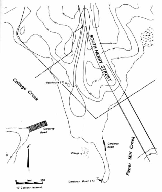 Figure 17. Archaeological features on City-owned land.
land roughly 250 feet away (Figure 18). The eastern half of the road has apparently washed away as the creek cut its present channel, but the western half, submerged at high tide, is clearly visible during low water periods.
Figure 17. Archaeological features on City-owned land.
land roughly 250 feet away (Figure 18). The eastern half of the road has apparently washed away as the creek cut its present channel, but the western half, submerged at high tide, is clearly visible during low water periods.
The extant structure of the road was not physically inspected, since it was located outside the boundaries of the City owned property. In form, however, it appears similar to the corduroy road along Paper Mill Creek (see below), being composed of side by side smooth logs set carefully in place. Now firmly entrenched in a matrix of sticky black mud, its seems unlikely that this portion of the road will be destroyed unless there is construction on the western side of College Creek or the creek is forced to seek a new channel once again.
Paper Mill Creek Corduroy Road
The corduroy road along Paper Mill Creek can be seen on the eastern bank of the southward extending spit that divides College Creek from this marshy tributary (Figures 19-21). As seen at low tide, the corduroy road in fact consists of two tiers of smooth, 4 inch diameter logs. The logs, probably cedar, are somewhat pointed at the end. The two tiers are separated by some 1.3 feet of black loamy mud, and only the upper tier is clearly visible at moderate to high tide.
Although the road appears exposed only along this bank, there is reason to believe that it extends the entire length of the spit; in fact, the spit may have formed by the accumulation of silt and mud along the road, raising it to a finger of land that was later colonized by marsh grass. The marsh grass, up to six feet high in places, serves to anchor the mud and thus mask the corduroy road lying underneath.
At the very end of the spit, at the mouth of Paper Mill Creek, is a structure that suggests a possible renovation of the road. An L shaped reinforcing frame has been built from 2 x 4 inch planks driven vertically into the ground, and supported by large 6 inch diameter logs. Equally large 6 inch diameter logs have been placed side by side inside the frame; unlike the structure seen on the western bank of Paper Mill Lagoon, these Lagoon, these logs are not pointed. Only a few logs are visible, but it appears that they once covered the entire 20 feet or so across the mouth of Paper Mill Creek (Figures 22 and 23). As the reinforcing frame is off set from the likely path of the corduroy road revealed in the spit, it appears that this new crossing was rebuilt after the old corduroy road had partially washed away. Two upright metal pipes and a square headed lag bolt protrude from the mud in and around the frame, but it is not clear whether they are associated with the frame's construction. No clearly associated artifacts were found with which to date this renovation.
Wharf Pilings
Located on the tidal flat west of the Paper Mill spit is a group of at least 28 wooden pilings. These pilings, made of 10-12 inch diameter cedar logs, are fully exposed only at low tide and remain almost totally covered by a sticky, dark brown mud.
The pilings form no clear pattern, but appear to consist of several lines of piles, 5 to 10 feet apart (Figure 24). Indications are that the shoreline was once farther out, and the now almost submerged pile tops would then have been raised well out of the water. No artifacts were found in association with the piles, however, and thus the exact date of the structure cannot be determined. They probably formed some sort of wharf or jetty.
Twentieth Century Trash Pit
The most artifact rich deposit found during the investigation was a large trash pit, at least 2.5 feet deep, on the eastern side of the landing. Included in the trash pit
30
 Figure 18. Corduroy road crossing College Creek.
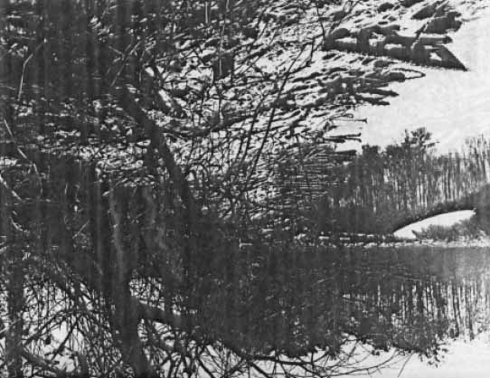 Figure 19. Corduroy road along Paper Mill Creek.
31
Figure 19. Corduroy road along Paper Mill Creek.
31
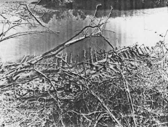 Figure 20. Corduroy road along Paper Mill Creek.
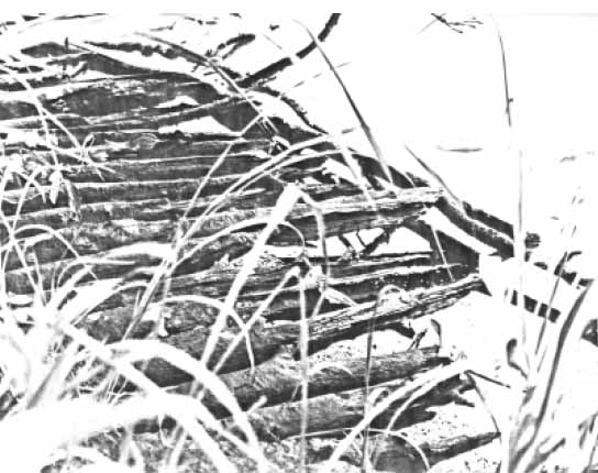 Figure 21. Detail of Corduroy road on Paper Mill Creek.
32
Figure 21. Detail of Corduroy road on Paper Mill Creek.
32
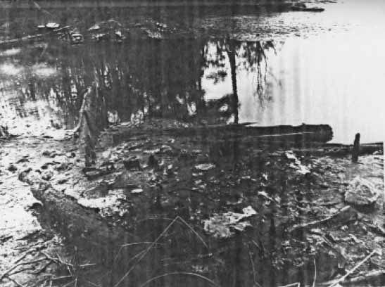 Figure 22. Reinforcing structure at mouth of Paper Mill Creek.
 Figure 23. Schematic drawing of reinforcing structure.
33
Figure 23. Schematic drawing of reinforcing structure.
33
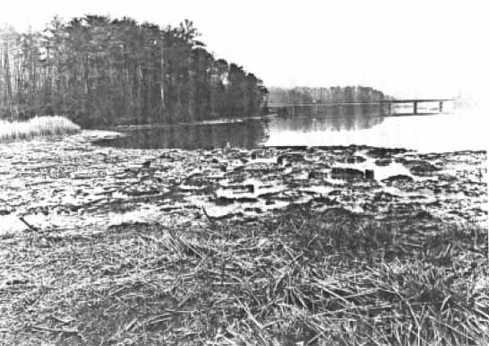 Figure 24. Wharf pilings on College Creek.
were some 50 glass containers, mostly beverage and pharmaceutical bottles, along with a few ceramics, some pieces of metal, and a large stoneware jug containing the skeletons of three unlucky mice. The assemblage was given a terminus post quem date of 1924, based on a Diamond Glass Company manufacturer's mark (Toulouse 1971). The great majority of the bottles were apparently made during the first two decades of the 20th century, and the lack of any bottles made after 1924 suggests that the trash pit was filled around the mid to late 1920s.
Figure 24. Wharf pilings on College Creek.
were some 50 glass containers, mostly beverage and pharmaceutical bottles, along with a few ceramics, some pieces of metal, and a large stoneware jug containing the skeletons of three unlucky mice. The assemblage was given a terminus post quem date of 1924, based on a Diamond Glass Company manufacturer's mark (Toulouse 1971). The great majority of the bottles were apparently made during the first two decades of the 20th century, and the lack of any bottles made after 1924 suggests that the trash pit was filled around the mid to late 1920s.
Virtually all of the bottles in the assemblage are machine blown. Most show an "Owens scar", a "distinctive, circular mark with 'feathering' edges, caused by the shears that cut off the gob of glass in the suction machines,… usually off center and [which] may sometimes even extend into the heel" (Miller and Sullivan 1984:93). This indicates that the bottles were blown on an Owens glass blowing machine, therefore postdating the introduction of the machine just past the turn of the century. By 1917 about 50% of the bottles in the United States were produced by such machines (Miller and Sullivan 1984); in this assemblage the percentage is considerably higher.
The bottles found at College Landing were produced by at least five glass manufacturers: the Owens Bottle Company, the Turner Brothers Company of Terre Haute, Indiana, the Illinois Glass Company of Alton, Illinois, the Hazel Atlas Glass Company of Wheeling, West Virginia, and the Diamond Glass Company of Royersford, Pennsylvania. Their distinctive logos, seen on the bases of the bottles, provide important dating information about the manufacture of the bottle itself (Figure 25).
34 Figure 25. Diagnostic marks on bottles: a. Owens scar; b. Owens Bottle Co. (1911-1929); c. Turner Bros. Co. (1915-1929); d. Illinois Glass Co. (1916-1929); e. Hazel-Atlas Glass Co. (1920-1964); f. Diamond Glass Co. (1924-present). Scale 1:1.
The contents of the bottles varied (See Figures 26-29). Many were beverage bottles, containing, among other things, Cliquot Club (Soda?), Chero Cola, and Coca Cola. Pharmaceutical, toiletry, patent medicine, and food and condiment bottles contained such things as French's Mustard, Rumford baking soda, "Little Bo Peep" ammonia, Vaseline, Hinds Honey and Almond Cream, Milk of Magnesia, "Pluto Water", Great Radium Spring Water, "Hick's Capudine for Headaches, 35 Colds and Gripp", "Virginia Dare Extract", and an unidentified product of Undertaker's Supply Company of Chicago, Illinois.
Old Road Bed
Found on the eastern side of the College owned land, this abandoned road bed consisted of a flat surface with, in places, a 3-4 foot wide depression between small mounded banks on either side (Figures 30 and 31). The road traversed a long flat ridge leading toward Paper Mill Lagoon before skirting a small knoll at the end of the ridge and dropping to cross the lagoon via a corduroy road. A small arm of the road diverged to continue up to the top of the knoll. Part of the corduroy road crossing the lagoon has been washed away, and the remainder is apparently covered by mud and vegetation.
Two auger tests in the road bed revealed no trace of clear stratigraphic layers, and no artifacts were recovered with which to date the use of the road. Judging from its size and orientation, it may have been a logging road.
Dumping Area
Unusual topographic features on the ridge top just east of South Henry Street led to the discovery of a dump area measuring some 100 by 200 feet in size. When inspected, the features turned out to be large piles of rubble and debris, up to 12 feet in height. The piles were scattered, but all appeared west of an abandoned road bed on the eastern edge of this ridge; it seems that this road was used for access into the area.
Five of the piles formed an almost perfect square on a flat portion of the ridge top, and the topography suggested the possible presence of a structure beneath (Figure 32). Because the depression in the middle of the square of mounds was occupied by a 40 foot high hickory tree, any structure underneath must have been abandoned for a considerable period of time. Auger tests of the mounds showed brick rubble and/or solid stone at a depth of 2-3 feet, but no structural evidence was uncovered.
Among the debris in the other mounds were part of an iron gutter and a few automobile fenders. Although the access road has been cut by a shallow ravine north of the dump area, several truck or jeep ruts near the road suggest that it has been used until comparatively recently.
Evidence indicates that the entire area has been used for dumping trash and debris for some time. If a structure was present on the flat, it would explain the presence of the access road. This structure, which may be as old as late 19th century, could have been associated with the farm on the east side of South Henry Street run by Eastern State Hospital.
36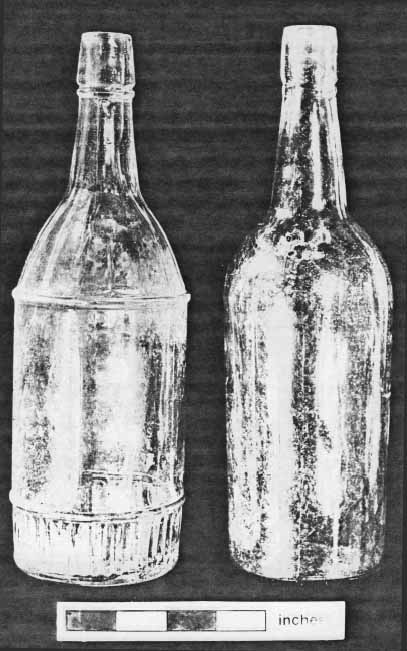 Figure 26. Early liquor bottles. Bottle on left is made on a semi-automatic machine (post-1889); bottle on right is hand blown into a mold (post-1880).
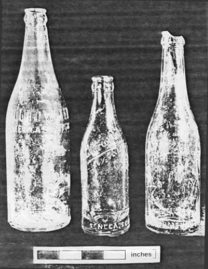 Figure 27. Early machine-made beverage bottles.
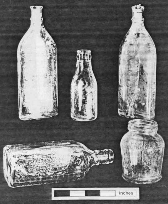 Figure 28. Various early machine-made bottles.
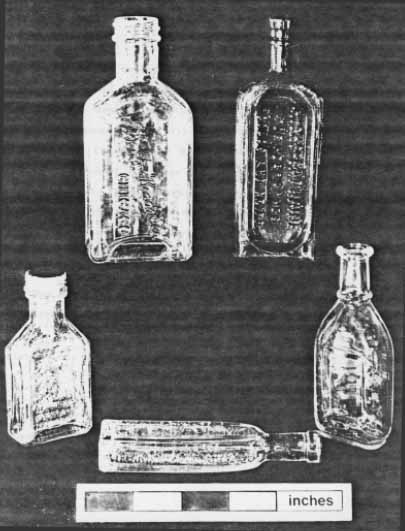 Figure 29. Panel bottles.
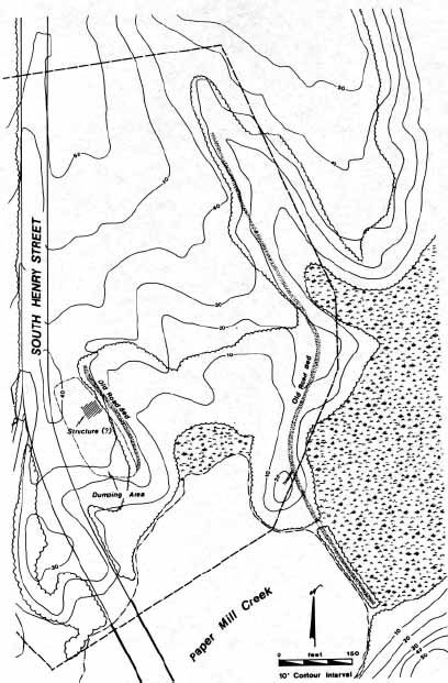 Figure 30. Archaeological features on College-owned land.
 Figure 31. Old road bed on ridge along Paper Mill Lagoon.
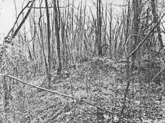 Figure 32. Possible structure on ridge east of South Henry street. Abandoned road bed is at left.
Recommendations
The 1985 investigation at College Landing was expected to reveal more evidence of the 18th century activities at the port. The filling and grading that has taken place in recent years has undoubtedly altered the landing considerably, while natural changes in the creek channels have resulted in a considerable amount of siltation and erosion. Many of these changes have served to protect the archaeological features at the landing, however; the possible warehouse remains, for instance, are now buried under some six feet of fill.
The remnants of the warehouse are now well protected, and it is recommended that the remainder of this feature should be preserved as is. The corduroy roads and wharf pilings are more immediately threatened by construction work or by vandalism, as they are fully exposed at low tide. It is recommended that they receive careful attention if City sponsored activities in the area place them in danger; in the meantime, the corduroy road on the west bank of College Creek should be fully documented, including measurements and close up photography.
The area on the eastern side of South Henry Street, now owned by the College of William and Mary, has been heavily disturbed by plowing, sand mining, and construction of the road. If this area is to be impacted by further construction activities, it is recommended that the parcel should be more thoroughly examined. The old road bed and the dumping area should be documented through historical research and/or archaeological testing.
An important portion of the College Landing community was not tested during the 1985 project. This is the west side of South Henry Street, an area now privately owned. Because it will be the site of a major housing development, this area should be intensively examined well in advance of full scale construction. It may well be that the concentration of colonial structures within the historically platted portion of the Landing can be preserved. Therefore, it should be surveyed and examined through test excavations as soon as possible so that delays in construction do not occur.
At least six 18th century structures might be expected on this parcel: the structures shown at the toe of the western ridge on the Berthier, St. Simon, and Desandrouins maps, one of which may be represented by an artifact scatter found by Hazzard in 1975 (Figure 33:#s 3, 4, 5 & 6); the two structures along the road shown on the Berthier map (Figure 33:#7); the structure on lot 2 shown on the Davenport plat and tested by Hazzard in 1975 (Figure 33:#10); and the rectangular structure shown much farther north on the St. Simon map (Figure 33:#9). This area appears to be the most undisturbed part of the entire College Landing settlement. As such, it is the only historically significant portion of the colonial port that survives for possible preservation and study.
43 Figure 33. Map-predicted sites and archaeological features in the entire College Landing area.
Bibliography
- 1781
- Camp a' Williamsburg le 26 Septembre 7 Miles de Archers hope. Princeton University Library, Bertier Papers, Numbers 21-37. Copy on file, Foundation Library, Colonial Williamsburg Foundation, Williamsburg, Virginia.
- 1699
- A Draft of the City of Williamsburg of Queen Mary's Port and Princess Anne's Port, Virginia. Special Collections, Swem Memorial Library, College of William and Mary. Copy on file, Foundation Library, Colonial Williamsburg Foundation, Williamsburg, Virginia.
- 1774
- Plan of Princess Anne's Port. Special Collections, Swem Memorial Library, College of William and Mary. Copy on file, Foundation Library, Colonial Williamsburg Foundation, Williamsburg, Virginia.
- 1781
- Carte des Environs de Williamsburg en Virginie. Library of Congress. Copy on file, Foundation Library, Colonial Williamsburg Foundation, Williamsburg, Virginia.
- 1775
- Virginia Gazette, 3 June 1775.
- 1779a
- Virginia Gazette, 27 November 1779.
- 1779b
- Virginia Gazette, 11 December 1779.
- 1979
- Virginia Colonial Abstracts, Series 2, Volume 4: James City County, Virginia 1634-1904. Southern Historical Press, Easley, South Carolina.
- 1930
- College Landing and Capitol Landing. Report on file, Foundation Library, Colonial Williamsburg Foundation, Williamsburg, Virginia.
- 1985
- Personal communication.
- 1809-1823
- The Statutes at Large: Being a Collection of All the Laws of Virginia, from the First Session of the Legislature in the Year 1619. 13 volumes. Samuel Pleasants, Richmond. 45
- 1977
- Historical Archaeology and Salvage Archaeological Excavations at College Landing: An Interim Report. Report on file, Virginia Research Center for Archaeology, Yorktown, Virginia.
- 1763
- Virginia Gazette, 4 November 1763.
- 1738
- History of the British Plantation in America. London.
- 1976
- A History of College Landing. Research Report No. 58, Foundation Library, Colonial Williamsburg Foundation, Williamsburg, Virginia.
- 1910
- Journals of the House of Burgesses 1619-1776. 13 volumes. E. Waddy, Richmond.
- 1984
- Machine Made Glass Containers and the End of Production for Mouth Blown Bottles. Historical Archaeology 18(2):83-96.
- 1972
- Flight and Rebellion: Slave Resistance in Eighteenth Century Virginia. Oxford Press, New York.
- 1884
- Calendar of Virginia State Papers. 11 volumes. Superindendent of Public Printing, Richmond.
- 1745
- Virginia Gazette, 19 September 1745.
- 1778a
- Virginia Gazette, 12 June 1778.
- 1778b
- Virginia Gazette, 10 July 1778.
- 1774
- Virginia Gazette, 16 April 1774.
- 1972
- Tidewater Towns: City Planning in Colonial Virginia and Maryland. University Press of Virginia, Charlottesville.
- 1771-1850
- Legal Cases and Estates, James City County. Folders 164 and 182, Tazewell Hall Estate. Special Collections, Swem Memorial Library, College of William and Mary, Williamsburg, Virginia. 46
- 1951
- Queen Mary's Port (Capitol Landing) Princess Anne's Port (College Landing), 1699-1800. Research Report No. 56, Foundation Library, Colonial Williamsburg Foundation, Williamsburg, Virginia.
- 1781
- Position of the Combined Army under Command of Major General Marquis de la Fayette. Newberry Library. Copy on file, Foundation Library, Colonial Williamsburg Foundation, Williamsburg, Virginia.
- 1971
- Bottle Makers and Their Marks. Thomas Nelson, New York.
| Context | Description | Unit | Munsell Value |
|---|---|---|---|
| WB3-001 | Topsoil | 2 | 10YR2/2 |
| WB3-002 | Yellow clay with sandy pebble | 2 | 10YR6/6 |
| WB3-003 | Light brown gray loam | 2 | 10YR4/3 |
| WB3-004 | Granular pebble | 2 | ——— |
| WB3-005 | Topsoil | 1 | 10YR3/2 |
| WB3-006 | Orange clay road base | 1 | 10YR6/8 |
| WB3-007 | Brown loam | 1 | 10YR3/2 |
| WB3-008 | Yellow brown silty clay | 1 | 10YR5/6 |
| WB3-009 | Silt | 2 | 10YR6/6 |
| WB3-010 | Hard clay with shell | 2 | 10YR7/6 |
| WB3-011 | Shell fragment wash | 2 | 10YR6/6 |
| WB3-012 | Gray sand | 1 | ——— |
| WB3-013 | Topsoil | 3 | 10YR5/3 |
| WB3-014 | Topsoil | 4 | 10YR5/3 |
| WB3-015 | Topsoil | 5 | 10YR5/3 |
| WB3-016 | Topsoil | 6 | 10YR5/3 |
| WB3-017 | Topsoil | 7 | 10YR5/3 |
| WB3-018 | Topsoil | 8 | 10YR5/3 |
| WB3-019 | Topsoil | 9 | 10YR5/3 |
| WB3-020 | Topsoil | 10 | 10YR5/3 |
| WB3-021 | Topsoil | 11 | 10YR5/3 |
| WB3-022 | Topsoil | 12 | 10YR5/3 |
| WB3-023 | Topsoil | 13 | 10YR5/3 |
| WB3-024 | Topsoil | 14 | 10YR5/3 |
| WB3-025 | Topsoil | 15 | 10YR5/3 |
| WB3-026 | Topsoil | 16 | 10YR5/3 |
| WB3-027 | Topsoil | 17 | 10YR5/3 |
| WB3-028 | Subsoil | 3 | 10YR6/6 |
| WB3-029 | Subsoil | 4 | 10YR6/6 |
| WB3-030 | Subsoil | 5 | 10YR6/6 |
| WB3-031 | Subsoil | 6 | 10YR6/6 |
| WB3-032 | Subsoil | 7 | 10YR6/6 |
| WB3-033 | Subsoil | 8 | 10YR6/6 |
| WB3-034 | Subsoil | 9 | 10YR6/6 |
| WB3-035 | Subsoil | 10 | 10YR6/6 |
| WB3-036 | Subsoil | 11 | 10YR6/6 |
| WB3-037 | Subsoil | 12 | 10YR6/6 |
| WB3-038 | Subsoil | 13 | 10YR6/6 |
| WB3-039 | Subsoil | 14 | 10YR6/6 |
| WB3-040 | Subsoil | 15 | 10YR6/6 |
| WB3-041 | Subsoil | 16 | 10YR6/6 |
| WB3-042 | Subsoil | 17 | 10YR6/6 |
| WB3-043 | Grayish loam with orange clay | 18 | ——— |
| WB3-044 | Brownish clay loam fill | 19 | ——— |
| WB3-045 | Brownish loam | 20 | ——— |
| WB3-046 | Mixed orange clay and brown loam | 21 | ——— |
| 48 | |||
| WB3-047 | Orange clay fill with brick | 22 | ——— |
| WB3-048 | Reddish orange clay fill | 23 | ——— |
| WB3-049 | Brown loamy fill | 23 | ——— |
| WB3-050 | Orange clay fill | 24 | ——— |
| WB3-051 | Brown loamy fill | 25 | ——— |
| WB3-052 | Orange clay fill | 26 | ——— |
| WB3-053 | Orange clay fill | 27 | ——— |
| WB3-054 | Orange clay fill | 28 | ——— |
| WB3-055 | Brown loamy fill | 29 | ——— |
| WB3-056 | Orange clay fill | 29 | ——— |
| WB3-057 | Dark brown loam in square postmold | 2 | ——— |
| WB3-058 | Brownish yellow sandy clay | A | 10YR6/6 |
| WB3-059 | Dark gray sand | A | 10YR3/1 |
| WB3-060 | Washed and redeposited clayey sand | A | 10YR4/2 |
| WB3-061 | Circular brown loam stain | A | ——— |
| WB3-062 | Washed and waterlogged clayey sand | A | 10YR2/1 |
| WB3-063 | Crushed shell | A | ——— |
| WB3-064 | Gray and tan sand | A | 10YR3/1 |
| WB3-065 | Dark grayish brown topsoil | B | 10YR4/2 |
| WB3-066 | Orange clay fill | B | 10YR6/8 |
| WB3-067 | Silty sand with shell | B | 10YR5/4 |
| WB3-068 | Red and gray striated sand with orange clay | B | 10YR6/6 |
| WB3-069 | Light gray ash | B | 10YR7/1 |
| WB3-070 | Brick rubble | B | ——— |
| WB3-071 | Tannish gray sand | B | ——— |
| WB3-072 | Silty sand with crushed shell | B | ——— |
| WB3-073 | Gray sand | B | 10YR7/1 |
| WB3-074 | Gray sand with oyster shell | B | 10YR7/1 |
| WB3-075 | Orange clay fill | C | 10YR6/6 |
| WB3-076 | Dark brown loam | C | 10YR2/2 |
| WB3-077 | Dark brown loam with charcoal | C | 10YR2/1 |
| WB3-078 | Crushed shell lens | C | 10YR5/3 |
| WB3-079 | Crushed shell lens | C | 10YR5/3 |
| WB3-080 | Gray sand | C | 10YR7/4 |
| WB3-081 | Crushed shell | C | 10YR5/3 |
| WB3-082 | Orange clay fill | D | 10YR6/6 |
| WB3-083 | Tan clayey sand | D | 10YR5/3 |
| WB3-084 | Gray sand | D | 10YR6/3 |
| WB3-085 | Orange clay with gray and tan sand | E | 10YR6/6 |
| WB3-086 | Brick rubble pile | E | ——— |
| WB3-087 | Crushed shell pile | E | 10YR5/3 |
| WB3-088 | Charcoal | E | 10YR2/1 |
| WB3-089 | Brick rubble | E | ——— |
| WB3-090 | Burnt clay with pinkish ash | E | 10YR4/6 |
| WB3-091 | Charcoal | E | 10YR2/1 |
| WB3-092 | Gray sand with shell | E | 10YR7/1 |
| WB3-093 | Gray sand | E | 10YR7/1 |
| WB3-094 | Brick in College Creek embankment | — | ——— |
| WB3-095 | Brick in ditch on N side of landing | — | ——— |
Appendix 2.
Artifact Inventories
| Glass, colorless non leaded* |
| Glass, machine made bottle, green, "TUBORG" (19 fragments) |
| Nail fragment, wire |
| Brick |
| Mortar, sand and pebble based (3 fragments) |
| Coal |
| Shell, barnacle |
| Nail, iron |
| Bone, petrified |
| Glass, colorless non leaded* |
| Bone china, English |
| Glass, colored (9 fragments) |
| Glass, manganese solarized |
| Glass, colorless non leaded (4 fragments) |
| Glass, bottle, post Prohibition, embossed "FORBIDS…"* |
| Wire, aluminum |
| Token, aluminum, "LOOK/SAVINGS MEDALLION" |
| Nails, wire |
| Slag, bog iron |
| Ironstone* |
| Earthenware, unidentified, burned |
| Brick (2 fragments) |
| Coal (2 fragments) |
| Porcellaneous ceramic* |
| Nail, iron |
| Pipe stem, English* |
| American stoneware, "white" |
| Glass, colored (3 fragments) |
| Glass, bottle base, amber, Owens scar* |
| Nail, iron |
| Flake, quartzite |
| Glass, colorless |
| Glass, soda bottle base, colorless non leaded, non returnable* |
| Whiteware, plain |
| Cartridge, rimfire* |
| Glass, window |
| Glass, colorless non leaded* |
| Glass, ink bottle, colorless non leaded, burned* |
| Nail, wire |
| Bracket, iron |
| Chert/flint chunk |
| Porcelain, hard paste, English (?) |
| Redware, lipped bowl, slip trailed, clear lead glaze interior |
| Coal |
| Pearlware, plain |
| Porcelain, hard paste, English (?) |
| Glass, colorless non leaded (3 fragments) |
| Glass, large pitcher handle, manganese solarized* |
| Shotgun shell, center fire |
| Creamware, plain |
| Pearlware, plain (2 fragments)* |
| Porcelain, Chinese export, underglaze blue decoration |
| Stoneware, Westerwald blue and gray |
| Glass, window (2 fragments) |
| Glass, wine bottle, dark green (3 fragments) |
| Nails, hand wrought (2 fragments) |
| Unidentified object, iron |
| Bone (5 fragments) |
| Nails, hand wrought (2 fragments) |
| Curb chain, iron (5 links) |
| Bone |
| Yellowware, pitcher, white glazed interior |
| Graniteware/ironstone, coffee cup, undecorated |
| Porcelain, English hard paste, cup, gilded with polychrome handpainted overglaze decoration |
| 51 |
| American stoneware, jug with loop handle, clear lead glaze, par-tially dipped in iron oxide |
| Glass, hand blown bottle, light blue, narrow mouth (baking soda), lipping tool, cup mold, "RUMFORD" on one shoulder |
| Glass, hand blown liquor bottle, colorless, lipping tool, cup mold (>1880) |
| Glass, machine made bottle, manganese solarized, liquor (wine?), molded design, semi automatic valve mark on base (>1889) |
| Glass, machine made beer bottles, green, crown finish, Owens scar, mold numbers on base (5 bottles) (>1903) |
| Glass, machine made soda/beer bottle, colorless, crown finish, Owens scar, Owens Bottle Company logo on base (>1911) |
| Glass, machine made soda/beer bottle, light blue, crown finish, Owens scar, "BEAUFONT/TRADEMARK/REGISTERED" on shoulder front and back, "THE BEAUFONT CO. INC. RICHMOND,VA" around heel (>1903) |
| Glass, machine made soda/beer bottle, turquoise blue, crown finish, Owens scar, mold numbers on heel (>1903) |
| Glass, machine made soda bottle, light blue, crown finish, Owens scar, "TRADE/CLIQUOT CLUB/MARK" on one shoulder, "REGISTERED" on heel, "A" on base (>1903) |
| Glass, machine made catsup bottles, colorless, Owens scar, continuous thread finish, bottom half decorated by 16 flutes, Owens Bottle Co. logo on base (4 bottles) (c. 1919) |
| Glass, machine made pharmaceutical bottle, colorless, square with rounded edges, cork and seal finish, Owens scar, "UNDERTAKER'S SUPPLY CO./CHICAGO, ILL." on one side with 1-14 oz. gradations, Illinois Glass Company logo on base (>1916) |
| Glass, machine made milk bottle, colorless, crown finish, Owens scar, Owens Bottle Company logo on base >1911) |
| Glass, machine made condiment bottle, colorless, long neck, cork stopper finish, Owens scar, Illinois Glass Company logo on base (>1916) |
| Glass, machine made condiment bottle, colorless, wide mouth, cork stopper (?) finish, Owens scar, Hazel Atlas Glass Company logo on base (>1920) |
| Glass, machine made pharmaceutical bottle, colorless, cork stopper finish, Owens scar, Owens Bottle Company logo on base (>1911) |
| Glass, machine made pharmaceutical bottle, colorless, wide mouth, Owens scar, cork stopper finish, mold number on base (>1903) |
| Glass, machine made pharmaceutical bottle, colorless, short, wide mouth, cork stopper (?) finish, Owens scar, mold number on base (>1903) |
| Glass, machine made condidment jar, colorless, threaded finish, Owens scar, "IT'S FRENCH'S" on one shoulder, "DESIGN PAT'D FEB. 23-15" on base (1915) |
| Glass, machine made food/condiment jar, colorless, threaded finish, Owens scar, "McCORMICK & CO. BALTIMORE, MD" on heel, mold number on base (>1903) |
| Glass, machine made food/condiment jar, colorless, threaded (?) finish with zinc screw on lid intact, Owens scar, Hazel Atlas Glass Company logo on base (>1920) |
| Glass, machine made pharmaceutical/toiletry bottle, colorless, rectangular with flat chamfers, long neck, narrow mouth, lug finish with partial metal cap in place, Owens scar, Illinois Glass Company logo on base (>1916) |
| 52 |
| Glass, machine made pharmaceutical/toiletry bottle, colorless, narrow mouth, stopper finish, Owens scar, rectangular sloping sides, remains of label on one side ("LYNCH…G"), Illinois Glass Company logo on base (>1916) |
| Glass, machine made panel bottle, colorless, rectangular, cork stopper finish, Owens scar, "VIRGINIA DARE EXTRACT" on left panel, "VIRGINIA DARE EXTRACT CO." on right panel, Owens Bottle Company logo on base (>1911) |
| Glass, machine made panel bottle, colorless, sloping shoulders, inset panel on reverse, remains of paper label on obverse, ball neck, cork stopper finish, Owens scar, Illinois Glass Company logo on base (>1916) |
| Glass, machine made panel bottle, amber, cork stopper, Owens scar, "HICK'S CAPUDINE/FOR HEADACHES/COLDS AND GRIPP" on obverse, Owens Bottle Company logo on base (>1911) |
| Glass, machine made ammonia bottles, colorless, flattened ovals, cork stoppers intact, "LITTLE/BO PEEP/AMMONIA" on obverse, Owens scars (2 fragments) (>1903) |
| Glass, machine made soda bottle, aqua, crown finish, "CHERO COLA/6 ½ FL. OZ." on shoulder obverse and reverse, "SENECA, S.C." and "THIS BOTTLE NEVER SOLD" on heel, "CHERO COLA/4" on base (>1903) |
| Glass, machine made soda/beer bottle, colorless, basal half only, molded square and circle pattern, "PATENT PENDING D.O.C. B 47-4" and "MIN. CONTENTS 6 FL. OZ." on heel, "NORFOLK/VA" on base (>1903) |
| Glass, machine made "Coke" bottle, green, crown finish, hobble skirt, "COCA COLA/TRADEMARK REGISTERED/BOTTLE PATD NOV 16 1915" on obverse shoulder, "COCA COLA/TRADEMARK REGISTERED/MIN CONTENTS 6 FL. OZS" on reverse shoulder, "NEWPORT NEWS VA" on base (c. 1915) |
| Glass, machine made soda bottle, colorless, crown finish, cup mold, "GREAT RADIUM/SPRING WATER CO. INC/PITTSFIELD,/MASS." on obverse, Diamond Glass Company logo on base (>1924)* |
| Glass, machine made soda bottle, light blue, crown finish, cup mold, "LHC" on lip, "PLUTO WATER/AMERICA'S PHYSIC" on obverse shoulder, "PLUTO" beneath Pluto figure on base (>1903) |
| Glass, machine made container, colorless, round, decorated with 14 flutes, narrow mouth, lug finish, cup mold, "THE GREAT ATLANTIC & PACIFIC TEA CO." encircling shoulder, Turner Brothers logo on base (>1915) |
| Glass, machine made wide mouth container, colorless, round, decorated with 12 flutes, cap seat finish, Owens scar, Illinois Glass Company logo on base (>1916) |
| Glass, machine made panel bottle, colorless, finish broken off, Owens scar (?), "McCORMICK & CO./BALTIMORE" on obverse (>1903) |
| Glass, machine made panel bottle, colorless, recessed panel on obverse, threaded finish with zinc (?) cap intact,"HINDS/HONEY/AND/ALMOND/CREAM/A.S. HINDS CO./ PORTLAND/MAINE U.S.A." on panel, "A.S. HINDS CO./1C4 1A H 11" on base (>1903) |
| Glass, machine made panel bottle, colorless, ball neck finish, Turner Brothers logo on base (>1915) |
| Glass, machine made pharmaceutical bottle, cobalt blue, strapped flask shape, continuous thread finish, "MILK OF/[emblem]/MAGNESIA/REC'D IN U.S. PATENT OFFICE/AUG. 21, 1906/THE CHAS. H. PHILLIPS/CHEMICAL COMPANY/GLENBOOK, CONN." on obverse, Illinois Glass Company logo on base (c. 1919) |
| 53 |
| Glass, machine made panel bottle, colorless, rectangular with three recessed panels, continuous thread finish, Owens scar, "G.E. McBRADY & CO. [script]/CHICAGO" on obverse, Illinois Glass Company logo on base (c. 1919) |
| Glass, machine made jar, colorless, continuous thread, "TRADE MARK/VASELINE/CHESEBROUGH/NEW YORK" on obverse (c. 1919) |
| Glass, machine made jar, colorless, continuous thread (probably non standardized), "GELFAND'S/[Hazel Atlas Glass Company logo]/BALTIMORE" on base (>1920) |
| Glass, machine made cylindrical jar, colorless, continuous thread, "GELFAND'S/16/1C 677/BALTIMORE" on base (c. 1919) |
| Glass, machine made jar, colorless, continuous thread, Owens scar (?), Hazel Atlas Glass Company logo on base (>1920) |
| Glass, machine made soda bottle base, colorless, Turner Brothers logo on base (>1915) |
| Glass, leaded glass light bulb with copper alloy and glass base, colorless (>1895) |
| Glass, opaque white, canning jar lid liner (>1869) |
| Glass, opaque white, lid (>1869) |
| Glass, stemmed glass foot with mold lines, colorless non leaded |
| Bone, mouse (3 incomplete skeletons) |
| Stoneware, black exterior glaze, red paste |
| Creamware, saucer, plain* |
| Pipe stem, English |
| Nail, iron |
| Strap, iron |
| Wood, petrified (3 pieces) |
| Brick (2 fragments) |
| Mortar, shell |
| Nails, iron (2 fragments) |
| Spike, iron |
| Nails, hand wrought (2 fragments) |
| Nail, machine cut and headed* |
| Nails, iron (4 fragments) |
| Bone |
| Redware, coarse, bowl, greenish brown lead glaze |
| Redware, coarse, exterior brown lead glaze, interior brown lead glaze over white slip |
| Brick |
| Wood |
| Wood, charred (6 pieces) |
| Bone (5 fragments) |
| Brick (2 fragments) |
| Brick |
| Location | Elevation | Datum |
| Unit 1 | 3.62 | A1 |
| Unit 2 | 4.52 | A |
| Trench A, NW corner | 3.65 | A |
| Trench A, NE corner | -3.62 | A |
| Trench A, SW corner | 3.90 | A |
| Trench A, SE corner | 3.93 | A |
| Trench B, NW corner | 1.45 | A |
| Trench B, NE corner | 0.18 | A |
| Trench B, SW corner | +1.01 | A |
| Trench B, mid point on S wall | +0.30 | A |
| Trench B, SE corner | +1.40 | A |
| Trench C, NW corner | 0.29 | A |
| Trench C, NE corner | 1.30 | A |
| Trench C, SW corner | 0.67 | A |
| Trench C, SE corner | 1.22 | A |
| Trench D, NW corner | +1.20 | A |
| Trench D, NE corner | +1.47 | A |
| Trench D, SW corner | 0.42 | A |
| Trench D, SE corner | 0.09 | A |
| Trench E, NW corner | 0.92 | A |
| Trench E, NE corner | +1.77 | A |
| Trench E, SW corner | 0.32 | A |
| Trench E, SE corner | +0.91 | A |
| Unit 3 | +4.06 | B2 |
| Unit 4 | +3.73 | B |
| Unit 5 | +4.90 | B |
| Unit 6 | +5.57 | B |
| Unit 7 | +5.33 | B |
| Unit 8 | +1.13 | B |
| Unit 9 | —— | —3 |
| Unit 10 | —— | — |
| Unit 11 | +2.63 | B |
| Unit 12 | 0.10 | B |
| Unit 13 | +5.43 | B |
| Unit 14 | 2.27 | B |
| Unit 15 | +0.25 | B |
| Unit 16 | 0.33 | B |
| Unit 17 | +2.22 | B |